Map 0001: Difference between revisions
No edit summary |
No edit summary |
||
| Line 1: | Line 1: | ||
=Map Documentation: Poultry Farm Discovery (BDN)= | =Map Documentation: Poultry Farm Discovery (BDN)= | ||
<gallery mode="packed-hover" widths=200px heights=400px> | |||
Image:Map_0001.png|Detailed Avian Influenza Outbreak Map | |||
</gallery> | |||
==Abstract== | ==Abstract== | ||
This dataset provides a comprehensive list of **valid**, **open**, and **closed** poultry farms registered in the National Data Bank (BDN). It specifically filters for farms categorized as 'Breeding' (AL) or 'Mixed' (MS) across Italy. | This dataset provides a comprehensive list of **valid**, **open**, and **closed** poultry farms registered in the National Data Bank (BDN). It specifically filters for farms categorized as 'Breeding' (AL) or 'Mixed' (MS) across Italy. | ||
Revision as of 08:28, 10 February 2026
Map Documentation: Poultry Farm Discovery (BDN)
-
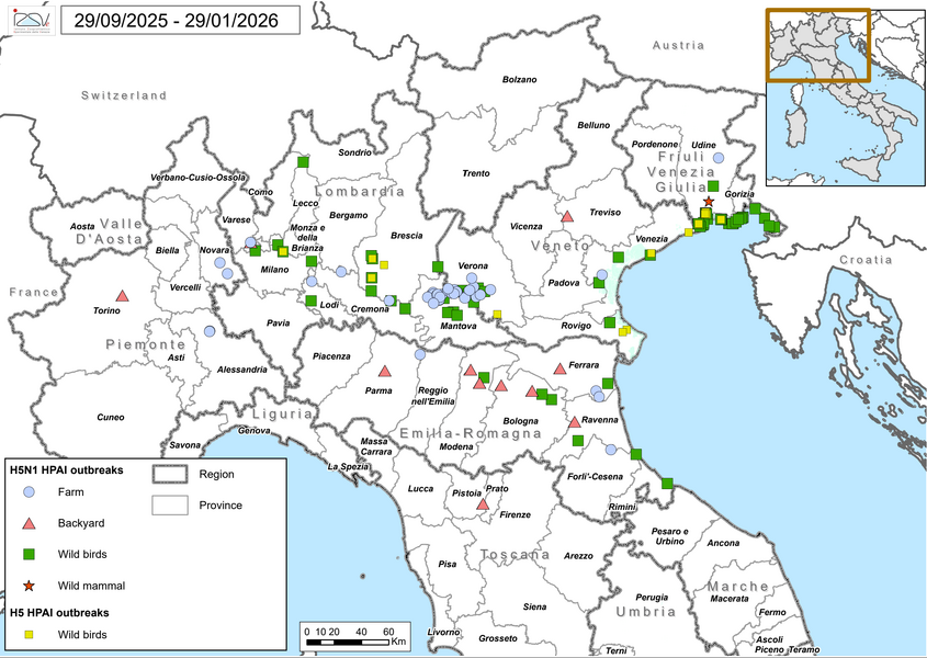 Detailed Avian Influenza Outbreak Map

Abstract
This dataset provides a comprehensive list of **valid**, **open**, and **closed** poultry farms registered in the National Data Bank (BDN). It specifically filters for farms categorized as 'Breeding' (AL) or 'Mixed' (MS) across Italy. The data is processed through a join between the poultry breeding facts and the 'Places' (Luoghi) dimension (filtered for valid/open locations). It also incorporates owner/holder details via an outer join with the 'Registry' (Anagrafe) dimension and housing data via the 'Poultry Housing' (Accasamenti) dimension.
General Details
- Owner: IZSVe - Istituto Zooprofilattico Sperimentale delle Venezie
- Source: National Data Bank (BDN) - DWH Fact: ALLEVAMENTI_AVICOLI
- Publication Date: 2017-01-01
- Destination:
- GIS Instance
- WebGIS
- Influenza Monitoring Portal
Geographic Information
- Coverage Area: Italy (National territory)*
- Coordinate Reference System: EPSG:32632 (WGS 84 / UTM zone 32N)*
- Geographic Unit:
- Municipality (ISTAT)
- ASL Competence Districts