World Status of Foot and mouth disease (FMD): Difference between revisions
m Paola moved page Map 0003 to World Status of Foot and mouth disease (FMD) |
|||
| (16 intermediate revisions by the same user not shown) | |||
| Line 1: | Line 1: | ||
=Map Documentation:Foot and mouth disease (FMD)= | =Map Documentation: World Status of Foot and mouth disease (FMD)= | ||
<gallery mode="packed-hover" widths=150px heights=300px> | <gallery mode="packed-hover" widths=150px heights=300px> | ||
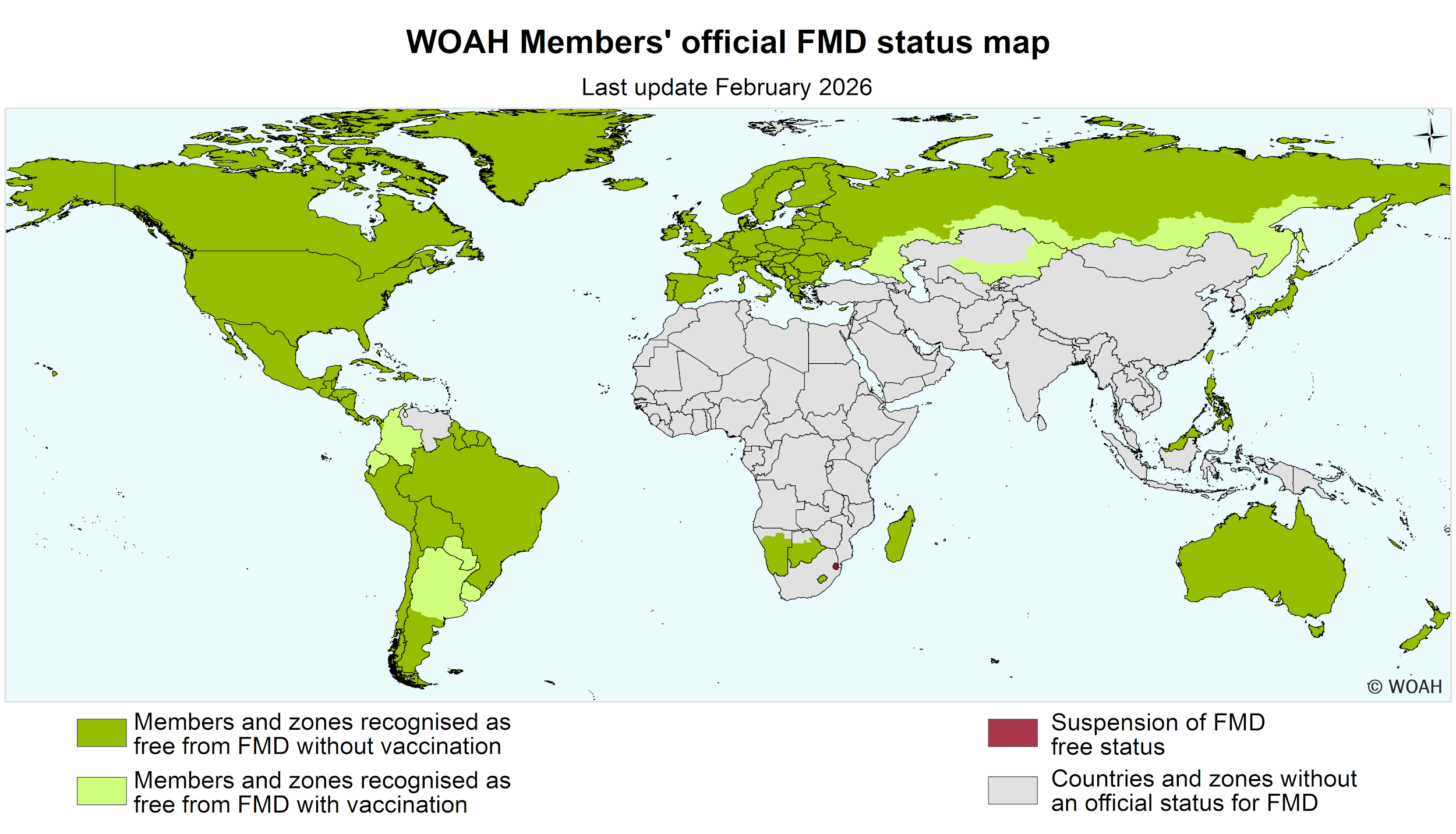
Image:Fmd-world-eng-2026.png | Image:Fmd-world-eng-2026.png</gallery> | ||
</gallery> | |||
==Abstract== | ==Abstract== | ||
The World FMD Map, maintained by the World Organisation for Animal Health ([https://www.woah.org/ WOAH]), tracks the global status of Foot and Mouth Disease. It categorizes members as FMD-free where vaccination is not practiced, FMD-free where vaccination is practiced, or as having specific disease-free zones. This recognition is vital for international trade under WTO agreements. The map is updated: status can be suspended or reinstated based on new outbreaks or successful control measures. | |||
==General Details== | ==General Details== | ||
*Owner: | *Owner: [https://www.woah.org/ WOAH] | ||
*Source: | *Source: https://www.woah.org/en/disease/foot-and-mouth-disease/#ui-id-2 | ||
*Publication Date: | *Publication Date: February 2026 | ||
*Destination: | *Destination: | ||
** | **WOAH Disease Status Department | ||
==Geographic Information== | ==Geographic Information== | ||
*Coverage Area: | *Coverage Area: World | ||
*Coordinate Reference System: EPSG: | *Coordinate Reference System: EPSG:4326 (WGS 84) | ||
*Geographic Unit: | *Geographic Unit: | ||
** | ** Country | ||
== Online Resource == | == Online Resource == | ||
| Line 32: | Line 27: | ||
|- | |- | ||
| '''Linkage''' | | '''Linkage''' | ||
| [[:Media: | | [[:Media:Fmd-world-eng-2026.png|Download Fmd-world-eng-2026.png]] | ||
|- | |- | ||
| '''Protocol''' | | '''Protocol''' | ||
| Line 49: | Line 44: | ||
==KeyWords== | ==KeyWords== | ||
{| style="margin: auto; width: 500px; background: transparent; border-collapse: collapse; text-align: center;" | {| style="margin: auto; width: 500px; background: transparent; border-collapse: collapse; text-align: center;" | ||
| | | FMD|| STATUS|| WOAH | ||
|} | |} | ||
[[CategorY:Map_Metadata]] | [[CategorY:Map_Metadata]] | ||
Latest revision as of 14:50, 17 February 2026
Map Documentation: World Status of Foot and mouth disease (FMD)
[edit]
Abstract
[edit]The World FMD Map, maintained by the World Organisation for Animal Health (WOAH), tracks the global status of Foot and Mouth Disease. It categorizes members as FMD-free where vaccination is not practiced, FMD-free where vaccination is practiced, or as having specific disease-free zones. This recognition is vital for international trade under WTO agreements. The map is updated: status can be suspended or reinstated based on new outbreaks or successful control measures.
General Details
[edit]- Owner: WOAH
- Source: https://www.woah.org/en/disease/foot-and-mouth-disease/#ui-id-2
- Publication Date: February 2026
- Destination:
- WOAH Disease Status Department
Geographic Information
[edit]- Coverage Area: World
- Coordinate Reference System: EPSG:4326 (WGS 84)
- Geographic Unit:
- Country
Online Resource
[edit]| Field | Value |
|---|---|
| Linkage | Download Fmd-world-eng-2026.png |
| Protocol | HTTPS / Wiki File System |
| Function | Download |
| Format | image/png |
| Description | Detailed resource for the specified geographical area. |
KeyWords
[edit]| FMD | STATUS | WOAH |