Map 0001: Difference between revisions
Created page with "{| style="width:100%; background:transparent; border-spacing:10px;" | style="width:100%; background:#ffffff; border:1px solid #ccc; padding:20px; border-radius:8px;" | right|192px == Map Documentation: [Map Name] == --- ### General Details * **Owner:** [Entity or Department Name] * **Source:** [Original Database, URL, or Data Provider] * **Publication Date:** [YYYY-MM-DD] * **Destination:** [e.g., WebGIS, Technical Report, Public Portal]..." |
|||
| (23 intermediate revisions by the same user not shown) | |||
| Line 1: | Line 1: | ||
=Map Documentation: Poultry Farm Discovery (BDN)= | |||
<gallery mode="packed-hover" widths=150px heights=300px> | |||
Image:Map_0001.png|Detailed Avian Influenza Outbreak Map | |||
</gallery> | |||
==Abstract== | |||
This dataset provides a comprehensive list of **valid**, **open**, and **closed** poultry farms registered in the National Data Bank (BDN). It specifically filters for farms categorized as 'Breeding' (AL) or 'Mixed' (MS) across Italy. | |||
The data is processed through a join between the poultry breeding facts and the 'Places' (Luoghi) dimension (filtered for valid/open locations). It also incorporates owner/holder details via an outer join with the 'Registry' (Anagrafe) dimension and housing data via the 'Poultry Housing' (Accasamenti) dimension. | |||
==General Details== | |||
*Owner: IZSVe - Istituto Zooprofilattico Sperimentale delle Venezie | |||
*Source: National Data Bank (BDN) - DWH Fact: ALLEVAMENTI_AVICOLI | |||
*Publication Date: 2017-01-01 | |||
* ** | *Destination: | ||
**GIS Instance | |||
**WebGIS | |||
**Influenza Monitoring Portal | |||
==Geographic Information== | |||
*Coverage Area: Italy (National territory)* | |||
*Coordinate Reference System: EPSG:32632 (WGS 84 / UTM zone 32N)* | |||
*Geographic Unit: | |||
** Municipality (ISTAT) | |||
** ASL Competence Districts | |||
# | == Online Resource == | ||
{| class="wikitable" style="width:100%; border: 1px solid #a2a9b1;" | |||
|- | |||
--- | ! style="background-color: #f2f2f2; text-align: left; width: 20%;" | Field | ||
! style="background-color: #f2f2f2; text-align: left;" | Value | |||
|- | |||
| '''Linkage''' | |||
| [[:Media:Map_0001.png|Download Map_0001.png]] | |||
|- | |||
| '''Protocol''' | |||
| HTTPS / Wiki File System | |||
|- | |||
| '''Function''' | |||
| Download | |||
|- | |||
| '''Format''' | |||
| image/png | |||
|- | |||
| '''Description''' | |||
| Detailed resource for the specified geographical area. | |||
|} | |||
==KeyWords== | |||
{| style="margin: auto; width: 500px; background: transparent; border-collapse: collapse; text-align: center;" | |||
| AVIAN || INFLUENZA || FARMS | |||
|} | |} | ||
[[CategorY:Map_Metadata]] | |||
[[ | |||
Latest revision as of 09:02, 11 February 2026
Map Documentation: Poultry Farm Discovery (BDN)
[edit]-
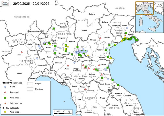 Detailed Avian Influenza Outbreak Map

Abstract
[edit]This dataset provides a comprehensive list of **valid**, **open**, and **closed** poultry farms registered in the National Data Bank (BDN). It specifically filters for farms categorized as 'Breeding' (AL) or 'Mixed' (MS) across Italy. The data is processed through a join between the poultry breeding facts and the 'Places' (Luoghi) dimension (filtered for valid/open locations). It also incorporates owner/holder details via an outer join with the 'Registry' (Anagrafe) dimension and housing data via the 'Poultry Housing' (Accasamenti) dimension.
General Details
[edit]- Owner: IZSVe - Istituto Zooprofilattico Sperimentale delle Venezie
- Source: National Data Bank (BDN) - DWH Fact: ALLEVAMENTI_AVICOLI
- Publication Date: 2017-01-01
- Destination:
- GIS Instance
- WebGIS
- Influenza Monitoring Portal
Geographic Information
[edit]- Coverage Area: Italy (National territory)*
- Coordinate Reference System: EPSG:32632 (WGS 84 / UTM zone 32N)*
- Geographic Unit:
- Municipality (ISTAT)
- ASL Competence Districts
Online Resource
[edit]| Field | Value |
|---|---|
| Linkage | Download Map_0001.png |
| Protocol | HTTPS / Wiki File System |
| Function | Download |
| Format | image/png |
| Description | Detailed resource for the specified geographical area. |
KeyWords
[edit]| AVIAN | INFLUENZA | FARMS |